
50km
Join us on Saturday June 13th at 6:15 am starting in Sinks Canyon for an epic mountain race.
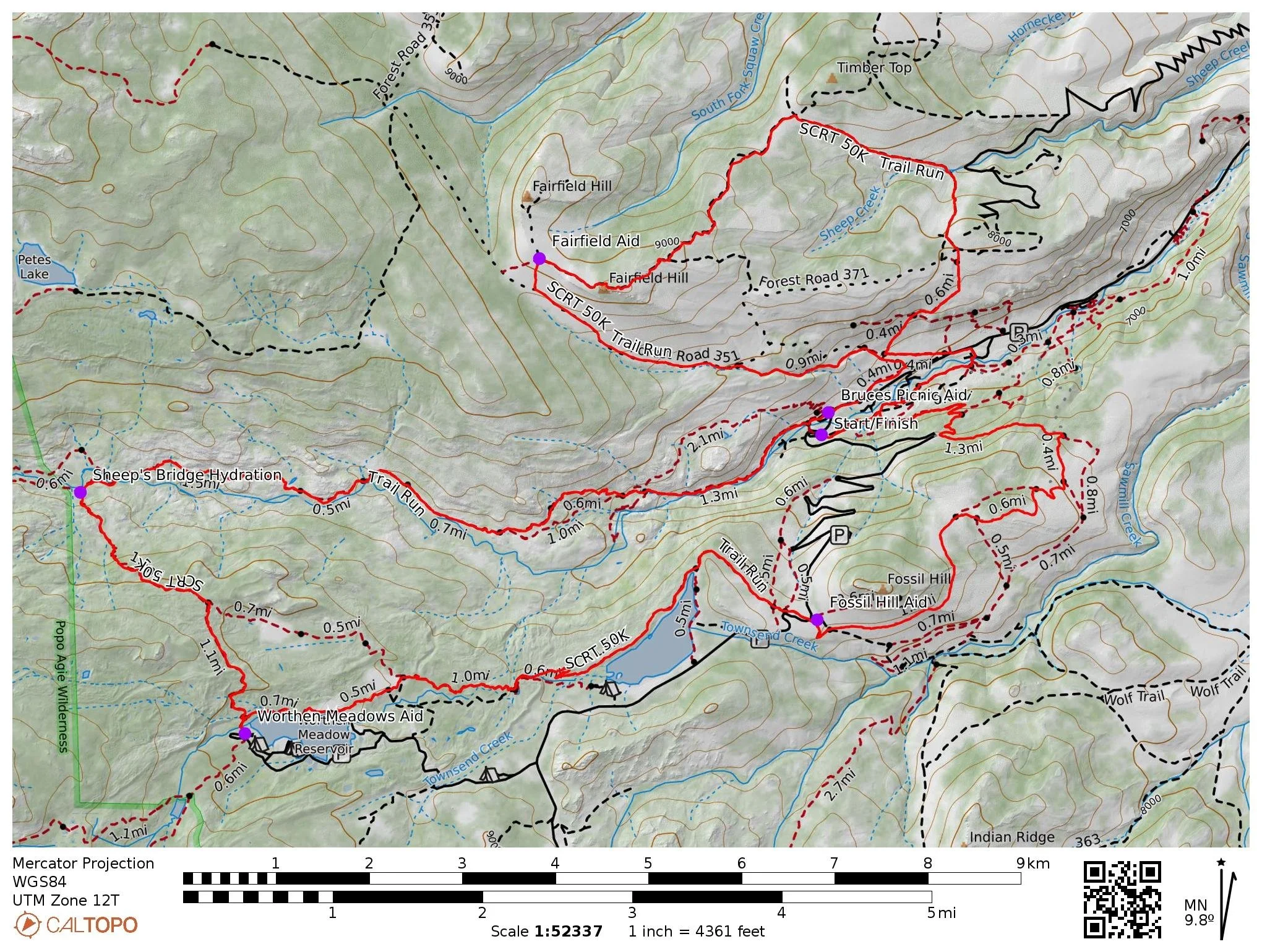
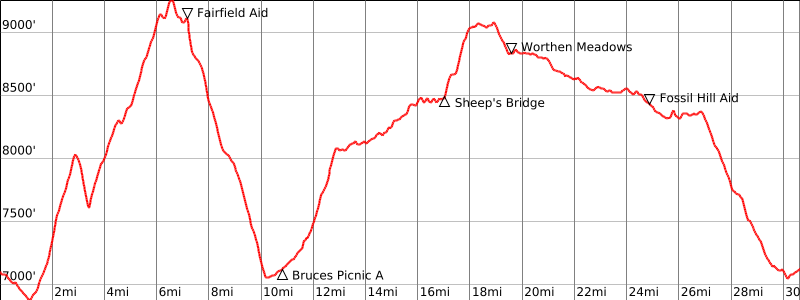
50K Course Map and Elevation Profile
Total Elevation Gain: 5800 FT
80% technical and swooping single-track, 19% rugged 2-track, 1% smooth pavement
Course Description
The 50K course is a legit mountain run. If you like to play hard in the mountains this is the run for you. Here is the route:
Start: Bruce’s parking lot enjoy the wildflowers of the mellow Sinks Canyon/River Trail until you get to the Sinks Canyon Campground. From there, cross the highway to a Climber’s trail and enjoy the steep single-track climb to the top of Fairfield ridge. From the ridge, you’ll do a steep and technical drop down to Sheep Creek and up another two-track through a sea of wildflowers to the Timbertop Mountain. Turn left, and begin the ascent to Fairfield Hill. Enjoy the panorama of the Wind River Mountains in front of you as you traverse the ridge on a two-track to Fairfield saddle. If you’re feeling groovy jump off the trail and quick bag the peak, the view is awesome.
Fairfield Aid Station (Mile 7.5): Meet our lovely volunteers at your first aid station. Tuck and roll off the Fairfield saddle and head downhill back towards Sinks Canyon. After scooting around some mud on the road, don’t miss the right turn onto some fun single track back down to the bottom of Sinks Canyon (this is what we call the “truck trail”). You will parallel the two-track for a short while until you reach a parking area near the bottom of the canyon. Take a hard right and follow the flagging through a grassy and faint trail behind the horse stables. This eventually takes you back to Sinks Canyon Road where you will run on the side for about 1/4 mile. Stay on the right side as your aid station will be just ahead at the Bruce’s Picnic area.
Bruce’s Picnic Aid Station (Mile 12): Turn right into the picnic area for your second aid station. Continue through the picnic area and meet up with the Middle Fork trail. Head up the rocky and beautiful single track for about 5.5 miles along Middle Fork of the Popo Agie River. Hang a left, cross Sheep’s Bridge, and meet the hydration station at mile 17.5. Volunteers will be filtering water to help ease the ascent to Worthen Meadows Reservoir. The section from Bruce’s Picnic has little tree coverage and can become hot.
Worthen Meadows Aid Station (Mile 20): Be sure to follow signage and go all of the way to the aid station, which will be located at the trailhead. You will go past the trail Upper Brewer’s Trail junction 1/10 mile and you must check into the aid station first. After checking in and receiving aid, go back up the Worthen Meadows trail 1/10 mile until you reach the Upper Brewer’s trail. You will run 5 miles along Worthen Reservoir, thick forest, open meadows, and Fry Lake. Once you reach Louis Lake Rad ) The Loop Rd, watch for vehicles and cross the road to meet the Fossil Hill Aid Station.
Fossil Hill Aid Station (Mile 25): Take the single track out of the aid station. When the single track meets up with the two-track and cattle guard, cross the road and hop onto the Brewer’s Trail to begin your traverse around Fossil Hill through wildflower heaven. Continue down the Brewer’s Trail to the bottom of the canyon and back to Bruce’s Parking Area for the finish.
Aid Station Information
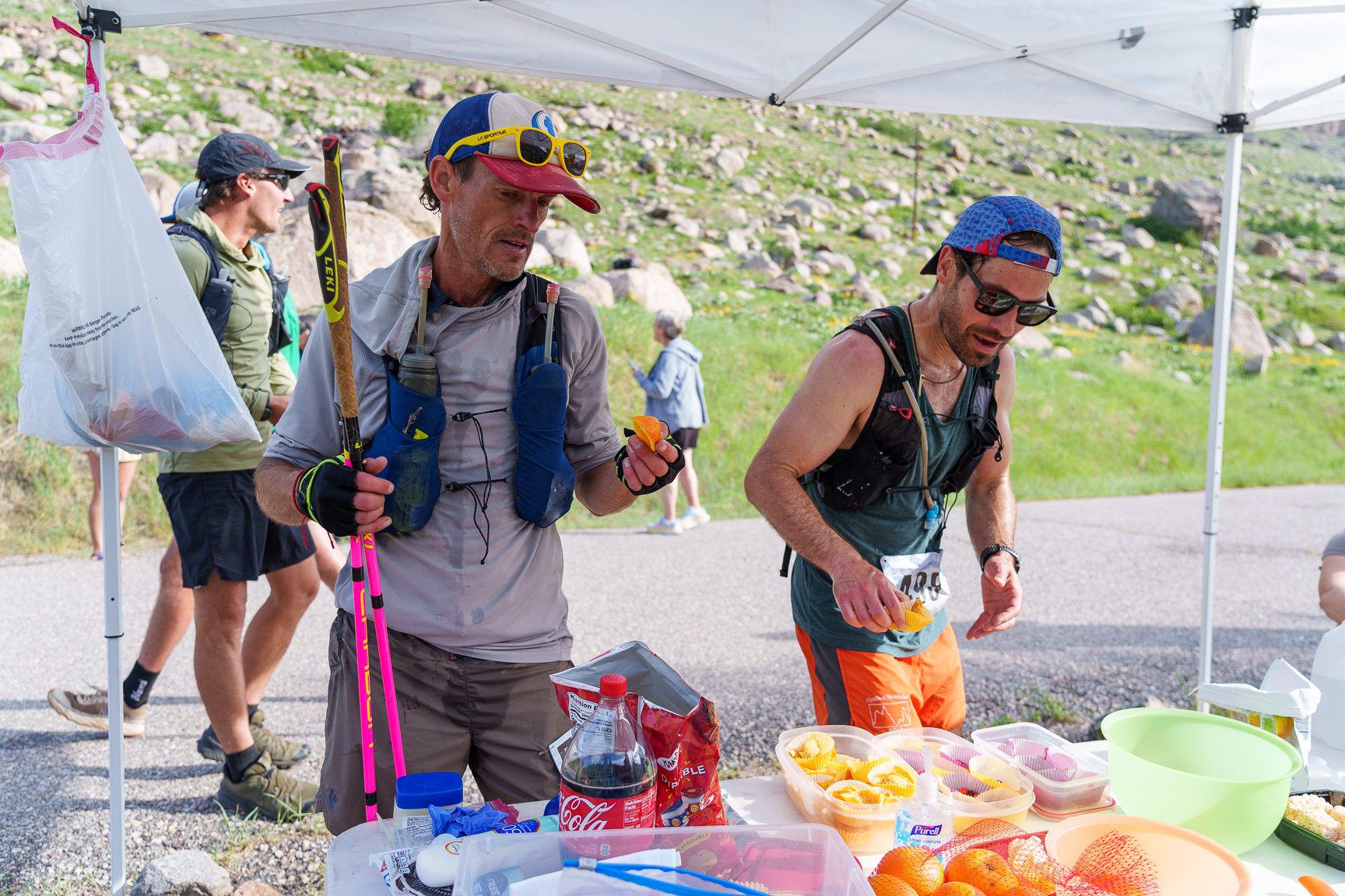
Full Aid = Water, Skratch drink, Maurten gels & bars, M&M’s, gummy bears, Fritos, potato chips, GF Oreos, oranges, Coke, Ginger Ale
Minimal Aid = Water, Skratch Hydration drink, Maurten gels, gummy bears, potato chips
Hydration = Water, Skratch Hydration drink
50K Rules
This is a cupless race—all 50k racers must carry a bottle that can hold a minimum of ½ liter. Carrying a full liter is recommended.
Racers must follow all trail markings and stay on the course.
Pacers are not allowed during the race.
Receive aid only within 50 meters of at aid stations.
Racers are required to check in and out of all aid stations.
Use the designated restrooms or go off trail a minimum of 10 meters away from other racers and spectators. Follow Leave No Trace principles.
Trekking poles may be used. Please be considerate and aware of surrounding racers.
Earbuds may be used in one ear. Please listen for racers behind you.
Dogs may not pace racers on the trail. Dogs may be leashed with spectators/crews and must stay a minimum of 30 meters from aid station and start/finish tents.
Drops bags need to be set at the designated location at the starting area race morning. Please clearly mark your drop bags with your name, aid station location, and race bib number.
Cutoff times have been calculated for each aid station based on a 10.25-hour finish. Elevation gain and time of day was also considered. If you miss a cutoff, please respect our wonderful aid station volunteers and enjoy your ride back to the finish with them, or with your crew.
Crew Directions
(Mile 12) From Start/Finish: Across the street from Bruce’s Parking Area. Please walk to this aid station from the parking area.
(Mile 25) From Start/Finish: Head up the canyon switchbacks (west) on Louis Lake Road (aka The Loop Road). You will drive up several switchbacks for 4.5 miles until you reach the parking area at the base of Fossil Hill. The aid station will be set up in the parking area. If you are crewing at the mile 20 aid station, Worthen Meadows, continue with the directions below before crewing here.
Directions to Worthen Meadows (Mile 20) From Fossil Hill parking area, continue up (west) Louis Lake Road. Continue for 2.5 miles. Check out the beautiful view of Wind River Peak on your way. Turn right onto Forest Service Rd 302 for 2.5 miles for a bumpy ride. You will pass the entrance for Worthen Meadows Campground, however, continue straight for 1/4 mile until you approach the parking area. The aid station will be set up near the toilets. Runners will check in the aid station for an outback.